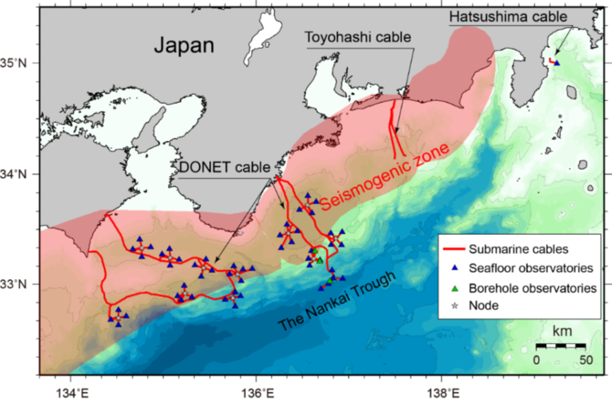
Background
For the past thousand years, devastating megathrust earthquakes, sometimes accompanied by huge tsunamis, have occurred repeatedly along the Nankai trough, off the southwestern coast of Japan. To constantly monitor the crust movements, in 2011 a permanent ocean floor observation network called the Dense Ocean-floor Network System for Earthquakes and Tsunamis (DONET) was deployed above the Kumano forearc basin to monitor crustal activities in the Nankai trough. DONET2 started in 2013 and it now covers the ocean floor between the Nankai trough and the cities of Shiono-misaki and Muroto.
 In 2015, the DONET2 stations observed tiny intermittent bursts of shallow very low frequency (VLF) earthquakes, with hypocenters in the accretionary wedge, a jumble of oceanic sediments scraped from the Philippine Sea Plate as it dives below the Eurasian continent. Shallow VLF earthquakes, a family of slow earthquakes, indicate crustal deformation in the subduction zone, but the generation mechanism of these peculiar type earthquakes has not been clarified yet.
The DONET arrays are different from ordinary in-line cable observation networks because clusters of DONET stations, like bunches of grapes, are deployed around nodes, to which they are linked with optical fibre cables. Each node is similarly linked to a backbone cable, thus densely covering the seafloor. Each DONET station is equipped with a strong-motion seismometer, which measures ground accelerations, a high-sensitivity broadband seismometer, that can record signals at a broad range of periods (as long as 360 seconds), and pressure gauges, which can detect tsunamis as well as crustal deformation. These instruments allow to detect and issue earlier warnings for large earthquakes and tsunamis compared with warning based on land observations alone. Slow earthquakes and slow-slip crustal deformation can also be monitored and have been shown to be interconnected. Intensive study of these crustal activities may help us make better preparations for the next large earthquakes. Additionally, a vertical array of seismometers, strain meters, porepressure gauges, and tiltmeters are installed in boreholes, providing a 3D monitor crustal deformation, which is linked by fibre-optic cable to the DONET backbone, transmitting data in real time.
Slow earthquakes and crustal deformation with durations lasting from 1s to as long as 1 year have been recorded. Shallow VLF earthquakes are characterized by the dominance of seismic signals longer than 10 seconds, unlike regular earthquakes of similar ground velocity. Shallow VLF earthquakes are the least studied among slow earthquakes because their activity affects only a limited area. Also, because they originate below the ocean floor, observations close to the source are difficult to obtain. Shallow VLF earthquake activity along the Nankai trough was first observed in 2002, and again in later years: 2004, 2009, 2011, and 2015, when the DONET networks detected swarms of VLF earthquakes. The sequence of activity, in which bursts off Shiono-misaki were followed by bursts south of Kii channel and in the Kumano fore-arc basin, is very similar to that observed in 2009. Together, the DONET network and borehole stations constitute an observation network that extends over 300 kilometers along the Nankai trough and covers more than half of the region in which clusters of shallow VLF earthquakes have been observed. Continuous monitoring of VLF activity immediately above the source clusters will reveal the spatiotemporal variations of the source characteristics, including stress levels. Yet, the number of sensors is now limited by the number of physical locations where seismometers and pressure sensors are located.
Vision
1. Using a Distributed Acusting System
In recent years, DAS technology has played a key role in geophysical activity monitoring. In particular, it has shown great potential in transforming the way in which geophysical phenomena are analysed by field experts. In earthquake seismology, one of the main challenges is to acquire a coherent signal from seismic waves, as they propagate through space and time. DAS has enabled seismologists to study earthquakes at high-spatial resolutions (i.e. of a few metres), across remote and harsh environments spanning large distances (hundreds of kilometres) in a cost-effective and practical way. DAS can transform a "dark" fibre optic cable into a dense seismic array of interconnected strain sensors. This is done by using an interrogator unit, which sends laser pulses into the fibre and measures the phase shift in the Rayleigh backscattered light between adjacent points on the fibre. A typical DAS system will generate very large volumes of data representing the cable strain in space and time. This information can then be used in AI-based system to classify the events.
Project Outcome: a new distributed sensor capable to monitor seismic activity along Cape Muroto with a spatial spacing of .33cm.
2. Using Machine Learning to discriminate hydro-acoustic activity
This immense scale of data acquisition has naturally led researchers to take advantage of Machine Learning (ML) methods to perform data analysis and develop models and tools that aid in both understanding and detection of earthquakes. Although a large body of work exists in the use of ML methods for seismic data analysis, mainly using features extracted from conventional seismometers, using DAS data for developing ML algorithms have not been widely explored in seismology.
As both spatial and temporal sampling rates have increased, the exponential rise in the volume of available experimental observations generated by DAS demanded more efficient systems for automated data analysis. As such, the labour intensive process of discriminating any type of geophysical event from other sources of acoustic energy can be eliminated or significantly reduced using ML approaches.
Project Outcome: a Convolutional Neural Network model that discriminates between three different types of events as recorded by a buried fibre optic cable on the sea floor in a seismically active region. The three events that the CNN model was trained to discriminate are: (a) geophysical activity (earthquakes, tectonic tremors, etc.), (b) non-geophysical activity (ship movements, airgun shots, etc.) and (c) background noise.